
The Durance River Valley Basin
One of three teams selected for the investigation of the planned spatial development of the 200km long Valley of the Durance River (from Cavaillon to Digne-les-Bains and Gap), initiated and closely followed up by a team of experts appointed by the PACA-Region.
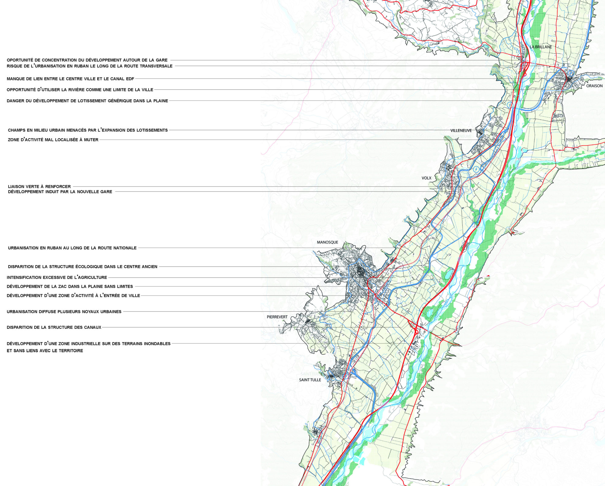
The basic problem of the Durance River changes along the sections: in the highest Alpine part, it is determined by the emigration of its dynamic population, leaving abandoned villages and hamlets and progression of natural wood sites. In the middle part, alluvial soils get to be extensively utilized for fruits and vegetable agriculture, destroying the configuration of the natural landscape. In the lower part, extensive urbanization, partly due to the Cadarache atomic research center and partly caused by national migration of elderly without great resources from north to south, is overtaken most of the countryside and value of the original landscape formation

Two-monthly meetings with the client, the three teams, and appointed experts, during which each team explains its advancement and gets feedback from the client and his experts. The interesting formula of parallel progression of three design teams, pursuing different hypotheses and stressing another socio-economic emphasis.
Concentrating on the lower and middle sections of the Durance Valley, the study advocated a set of successive, feasible interventions fitting within a landscape structure framework. The proposed policy is not aiming at an overall blueprint, but at a series of potential interventions sponsored by local stakeholders, that eventually lead to the restoration of an attractive and durable landscape structure at the larger scale of the Valley. In the lower part, this structure is based on the torrents and brooks descending from the hillsides at regular intervals. They give way to corridors of ecologic variety, cautiously integrated with evolutionary patterns of urban densification. In between these corridors, which also concentrate local traffic distribution, the deliberate assortment of crops organizes a mosaic of alternating fields.
In the middle part, the recreational attraction is of the agricultural landscape is increased by the introduction of bike lanes (also serving for connecting pockets of urbanization with the stops of a privileged public transport spine), following the horizontal dikes of the extensive network of channels created for energy production and irrigation. Many of these channels pass by historical monuments and valued buildings and sites. The framework of bike lanes can therefore work as a touristic circuit, opening up the area for a land-bound form of tourism, for which new sleeping and eating amenities on strategically located positions are proposed. The study inspired the Regional Board of Tourism to invest in a scheme of canal-based bike lanes.

Location
Durance, France
Year
2010 - 2011
Area
200 km
Program
Public Space, Infrastructure, Landscape
Collaborators
UapS (JOINT CONTRACT HOLDER), Plus office architects, Proap, Transversal, CITEC
Mission ORG
Urbanism, Masterplan
Team
Marcel Smets, Alexander D’Hooghe
Clients
Region Alpes – Provence - Cote d Azur


